History of Meghalaya, abode of clouds
Meghalaya is the “abode of clouds”. The two words, “Megham” (clouds) and “a-layam” (abode) from Sanskrit combine to get the name of this state. Meghalaya is one of the most beautiful states in Northeast India. This land is bestowed with exquisite scenic beauty, crystal clear waterfalls, and highland plateaus. This is one of the Seven Sisters States of this region. But the History of Meghalaya which we see today has a very long ancient root.
History of Meghalaya
Meghalaya, alongside neighboring Indian states, has been of archaeological interest. People have lived here since the Neolithic period. This is the period when the cultivation of cereals and animal domestication was introduced. The term Neolithic has a connection with agriculture. For livelihood, Meghalaya people still depend on agriculture. Even today jhum or shifting cultivation is practiced here.
Modern Meghalaya has a microcosm of diversity – a place that has witnessed many layers of migration. But the ancestors are Mongoloid. Mongoloid race originated from China, from where they migrated southward into the Malaya Peninsula and Indonesia. They entered India through the passes in the northern and eastern mountains. Presently, they occupy large areas in Ladakh, Sikkim, Arunachal Pradesh, Meghalaya, and other parts of North-East India. They are further classified as, a) Paleo-Mongoloids, and b) Tibeto-Mongoloids. Paleo-Mongoloids were the first who came to India and mainly settled in the border areas of the Himalayas. They are found mostly in Assam and the adjacent states. The tribes of Garo, Khasi, Jaintia, Lepcha, Chakma, and Naga belong to this race. However, the Khasi people all claim they are the descent from “Ki Hynniew trep” (Seven huts or families), seven Khasi sub-groups. They, are Khynriam, Pnar aka Jaintia, Bhoi, war, Maram aka Maharam, Lyngngam, and the extinct sub-group Dino.
Although Meghalaya, is a homeland of many tribes, three ancient tribes, the Khasis, Pnar aka Jaintias, and Garos are the chief inhabitants. They are communities of Paleo-Mongoloid descent. They are the earliest settlers in the present-day state. The Khasis inhabited the tract of Mountain territory, between the Jaintia and the Hills on the west occupied by Garos. In the Jaintia tract, Pnars aka Jaintias inhabited. The Achiks or Garos are closely related to the Bodos of Assam and belong to the Tibeto-Burman family while the Khasis and Pnars come from the Mon-Khmer family.
Before the advent of the British, there were around 30 states in the Khasi hills. Each state had an elected chief and each chief had a council to advise the chief and accord sanction on important business issues.
Rise and Consolidation of British Power
The Khasi and Pnar communities were adept in trade and commerce and their influence was spread from hills into the plains of Sylhet (present-day Bangladesh). They were doing trades in Limestone, Iron, Silk, Wax, Ivory, Honey, etc. Limestone and iron were some of the major exports from the region. The quality of Limestone from this area was excellent and was sent to Dhaka and Kolkata through Sylhet. In 1765 the British came to Sylhet when the East India Company (Company) acquired the Dewani of Sylhet from the Mughals.
After this acquisition, the British became a close neighbor of the Khasis and they soon realized the tremendous potential of trading with them. According to Historian David Laden, by 1799 the British somehow using their power established a monopoly over the Limestone business in that region. Further with the discovery of coal, they began to monopolies the coal trade also. The story twisted further in 1824 when the British were firmly entrenched in most of the sub-continent.
That was the period when the Burmese invaded Assam and Manipur states. To deal with the Burmese empire the British tried developing diplomatic relationships with the Khasi-Pnar tribes, as they wanted to build corridors through the hills for easier access to the Assam plains. In November 1823, David Scott was appointed Agent to the British Governor-General of India and was entrusted with the responsibility of consolidating the administrative power in the Northeast. Till that time the British were following a non -intervention policy concerning the Khasis state.
However, Scott wanted the British government to establish control over all the Khasi Chiefs. The Government of Bengal subsequently endorsed the view of Scott thus heralding a change of policy. Scott started negotiations with Khasi Chiefs for corridors, but he faced stiff resistance from some unwilling chiefs and royals who did not trust their trespass of independent tribal lands. Now to achieve his objective Scott resorted to a policy of coercion and negotiation. He ordered the closure of the markets in the plains to Khasi traders. He further stated that he would annex the area named Bardwar, in the plains which were then controlled by the Syiem of Nongkhlaw.
But he further indicated that a normal trade relationship at Bardwar would be maintained and it would remain a part of Hima Nongkhlaw, provided the Syiem U Tirot Singh (the constitutional head of Nongkhlaw) permits the Company to Construct his connectivity linking the Surma (Barak) valley and the Brahmaputra (Assam) valley.
Scott further wanted Tirot Singh to deal with all the Khasi chiefs for their consent to the East India Company, as the road would further affect areas beyond the jurisdiction of Nongkhlaw Syiem. Tirot felt it will help his community and hence agreed to it. He conveyed an assembly at Nongkhlaw and messages were sent to all the Khasi Syiems to attend the meeting. On 3rd November 1826, all Khasi Syiems arrived at Nongkhlaw to attend the meeting. The meeting lasted for nearly two days and ended in favor of the proposition. A treaty was signed with the British government. Accordingly, the Khasi’s agreed to aid the British government in the construction of the road, furnish labor and materials, donate lands for building residential Quarters, and protection to the British troops. Immediately after the survey, road construction work was started.
Edward Albert Gait, a British Administrator, in his book, “The History of Assam”, mentions that around early 1829, while the work was being carried out, someone informed Tirot Singh that the British had ulterior motives about the project and that they wanted to levy taxes and subjugate them as soon as the project was completed. Tirot Sing was also annoyed with the British for a few other reasons, out of that in one incident Scott did not keep his promise of restoring Bardwar to him.
This enraged the Khasis as they felt cheated, for their trust had been broken. He immediately called for a durbar (assembly) with David Scott and others, raised his concerns, and requested the British to vacate Nongkhlaw. Prof P N Dutta in his book ‘Glimpses into the History of Assam, Shillong 1996’ mentions that on 8 April 1829, Tirot Sing led an attack on a small group of British officers and killed them.
That was the beginning of the Anglo-Khasi war. This war was the conflict of Patriotism against Imperialism, between Justice and Injustice, a conflict that represents the Universal love for freedom, peace, harmony, and friendship without racial discrimination.
FREEDOM MOVEMENT
The Nongkhlaw incident brought unity among the Khasi Syiems in a move to oust the British from the land. After realizing the threats from the British, other Syiems gave their full support to Tirot Singh. Chiefs who supported the movement were the Syiems of Myriaw, Jirang, Rambrai, Mawsynram, Bhowal, Nongpoh, Maharam, Mawieng, and other petty units. Efforts were made to get support from the rulers of Jaintia hills, Bhutan, the Ahomking Chandrakanta, and the Singphos for their help to oust the British. The Khasi states that remained neutral were, the Khyriem, Langrin, Nongspung, and Nongstoin. Except for U Duwan Singh of Cherra who was a cluster ally of the East India Company. All these neutral states remain the silent spectator. War broke out at two fronts, Kamrup and Sylhet of the Khasi border. Tirot Singh fought the British armies for the next four years. The British had modern arms and ammunition like Guns to fight the war, whereas Khasis were fighting the battle with swords and arrows only. Tirot Sing countered the colonial forces largely with his guerrilla tactics.
But ultimately on 9th January 1833, the British mischievously succeeded to arrest Tirot Sing. He was deported to Dhaka and confined in the Dhaka Central Jail. On 17th July 1835, he passed away while still in confinement at Dhaka. 17 July is commemorated as U Tirot Singh Day in Meghalaya.
With the capture of Tirot Singh, the British rapidly started taking steps to complete the annexation of the Khasi hills. The company focussed on administration, concentration, and consolidation of power in the hills. They made the office of the Political agent to the Governor-general at Cherrapunji, who was in charge of developing a relationship between the Company and the Khasi states. The neutral and ally states, Nongspung, Khyrim, Nongstoin, Langrin, and Cherrapunjee were recognized as Independent states under the company. The states which took an active part in the uprising were punished and recognized as semi-independent states. Some small villages were confiscated from the native rulers and annexed by the British Government.
On 29th March 1834, the British inducted Rajan Singh as Syiem of Nongkhlaw, who allowed the British government to construct the road across his territory and agreed to supply labor and materials whenever they needed. Later, in 1835, the British incorporated Meghalaya into Assam. But on pen and paper, the region continued enjoying the status of semi-independent states under a relationship treaty signed between them. In 1836, another movement against the British took place under the leadership of Syiem Sngap of Maram, who resisted the British occupation of their land.
The agitation lasted till 1839 when the British with its superior force compelled the Syiem Maram to surrender. Thus, the British became the Paramount power in Khasi hill. The chiefs were allowed to retain entire jurisdiction within their limits, but they hardly had any power to administer their state. Thus, we find that though on paper every possible care was taken to retain the independence of the Khasi chief, gradually the line of distinction was obliterated and all the Khasi states sank into the position of dependent principalities. The power of the Syiems ultimately eroded. In 1859, on the plea of treaties of loyalty signed by the Syiems, the government introduced a bill to acquire land for military and civil purposes, under this they got the power to transfer free land and wasteland into government land.

Modern history of Meghalaya
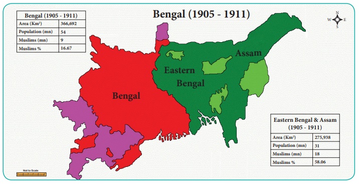
On 16 October 1905, Lord Curzon, the then Viceroy of India partitioned Bengal into two provinces:
- First was Bengal comprising Western Bengal as well as the provinces of Bihar and Orissa. And
- The second was Eastern Bengal and Assam.
Calcutta was the capital of Bengal while Dacca was chosen as the capital of Eastern Bengal. Meghalaya became a part of the new province of Eastern Bengal and Assam. Due to widespread political unrest, on December 12, 1911, King George V announced that eastern Bengal (districts where Bengali was spoken) would be absorbed into the Bengal Presidency. This time new provinces were established along linguistic lines. Bengal was divided into the provinces of Bihar and Orissa. Assam was separated into its province. Lord Hardinge the Viceroy annulled the partition of Bengal in 1911.
After the reversal of partition in 1911, Meghalaya became a part of the province of Assam. On 3 January 1921 in pursuance of Section 52A of the Government of India Act of 1919, the Governor-General-in-council declared the areas (now in Meghalaya), other than the Khasi states, as “backward tracts”. Subsequently, the British administration once again enacted the Government of India Act 1935 and regrouped the backward tracts into two categories: “excluded” and “partially excluded” areas.
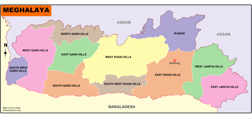
In 1947, the day India became independent. Meghalaya constituted two districts of Assam and enjoyed limited autonomy within the state of Assam. When Assamese became the state’s language in 1960, tribals objected and a movement for a separate hill state began. But unlike in many other hill regions in India, the movement was largely peaceful and constitutional. On 11 September 1968, the Government of India announced a scheme for constituting an autonomous state within the state of Assam comprising certain areas specified in Part A of the table appended to paragraph 20 of the Sixth Schedule to the Constitution. Accordingly, the Assam Reorganisation (Meghalaya) Act of 1969 was enacted for the formation of an autonomous state. Meghalaya was formed by carving out two districts from the state of Assam: a) the United Khasi Hills and Jaintia Hills, and b) the Garo Hills.
The name ‘Meghalaya’ as suggested by geographer S.P. Chatterjee in 1936 was proposed and accepted for the new state. The Act came into effect and Meghalaya became an autonomous state on 2 April 1970. On 21 January 1972, Meghalaya attained complete statehood status with its own Legislative Assembly.
Geographical Position of Meghalaya
Meghalaya covers an area of approximately 22,430 square kilometers. The state is bound to the south by the Mymensingh and Sylhet divisions of Bangladesh and to the west by the Rangpur division of Bangladesh. The north and east of the state are bounded by the State of Assam. English is the official language of the state.

Meghalaya’s Landscapes
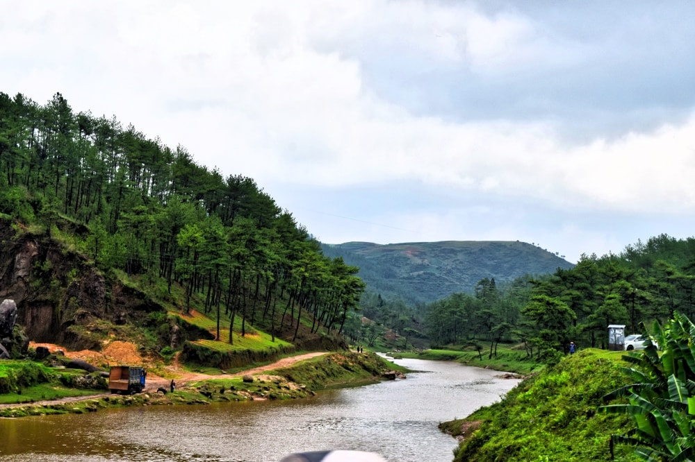
Visiting Meghalaya is a lifetime experience. The landscapes of the state are truly unforgettable. Nature blessed this place with the best of floras and faunas. The biodiversity of the state is well-diversified. The table-top heights of Sohra (Cherrapunjee) are brim-full with waterfalls, streams, and forest trails. Gaze at the Bangladeshi plains from the many vantage points on the state’s southern ridges. The outskirts of Shillong and the high plateau around Mylliem and Smit offer postcard-perfect representations of the simple life – complete with pastel green meadows, tall pine groves, crisp cool air, divine tribal smile, and quiet villages with quaint cottages and wooden fences spread across the countryside.
Further in the west, the Garo Hills burst into all the shades of green that you can think of. Here you can travel on winding roads that pass through undisturbed lush green dense forests where pachyderms and predators still rule and discover rarely-breached ecosystems. The state’s agrarian society has further contributed to this vibrant mosaic. Large and neat Paddy fields and deep green betel plantations add extra beauty to the state.

The views on the eastern part of the state, at Jaintia Hills, are even more enchanting. Many areas remain unexplored in this region. The world’s best quality spices have their home here.
Meghalaya has more than 1650 known caves and cave locations. The state has some of the longest and most complex cave systems in the world – from west to east, there are many subterranean tunnels and spots marked with ancient fossils and home to rare species.
The world’s longest sandstone cave named Krem Puri is discovered here near Laitsohum village in the Mawsynram area in the East Khasi Hills district. It has a staggering length of 24.5 km, almost three times the height of Mount Everest, and contains some dinosaur fossils from 66-76 million years ago as well. The dinosaur fossils in the longest sandstone cave in the world include those of the Mosasaurus, believe paleontologists. It was a carnivorous aquatic lizard that resided on Earth around 66-70 million years ago. During the monsoons, the fast-moving rivers swell and drop into the plains in imposing, powerful cascades – a reason why Meghalaya has also been termed a land of waterfalls.
The Wild Frontiers
Meghalaya is a part of the Indo-Burma biodiversity. Wildlife enthusiasts and research scholars from all over the country prefer this place for its great biodiversity, due to its high species diversification and high level of endemism. The rare and highly endangered Clouded Leopard is found in the forest and is declared a State Animal. Amongst other carnivores, are Leopards, Leopard cat, Jungle cat, Golden Cat, Marbled Cat, Indian Wild Dog (Dhole), and Indian Wolf.

Herbivores commonly found here are Elephants, Gaur, Sambar, Serow, and Barking deer. Omnivores are Jackals, Common foxes, Sloth bears, Himalayan Black bears, Large Indian civets, Yellow-throated Marten, Mongoose, Hog Badger, etc. The primates found in the State are Slow Loris, Pig Tailed Macaque, Hoolock Gibbon, Capped Langur, Stump Tailed Macaque, and Rhesus Macaque. Out of these, Hoolock Gibbon, and Capped Langur are globally declared endangered species.
Bengal Monitor Lizard, Water Monitor Lizard, and various snakes like the King Cobra, Indian Cobra, Rock Python, Vipers, Keelbacks, Banded Krait, Vine snakes, Trinket snakes, Wolf snakes, Rat snakes, flying snakes in Reptiles species are found in the State.
In birds, the state has many varieties. The Himalayan Grey-headed Fish Eagle, Black or King Vulture, Long Billed Vulture, White-backed Vulture, White-legged Falcon, White-cheeked Hill Partridge, Tawny Fish Owl, Kingfisher, Sprangled Drongo, and Grey Sibia Right are widely available here. Also, Meghalaya is the home of the extremely rare Rufous Necked Hornbill, the Darter, Dordon’s, or Blyth’s Baza Painted Stork. More than 600 bird species apart from any migratory are recorded from different Wildlife Sanctuary. The rivers of the state are clean and have abundant water almost throughout the year. This supports a lot to its wildlife. The Golden Mahseer, as disappeared from the rivers and streams in other states can still be found in the river Umtrew at Ri-Bhoi district.
The Seasons of Meghalaya
A short monsoon drive south of Shillong will take you to some of the wettest places on earth – Sohra (Cherrapunjee) and Mawsynram. July to August is the full monsoon season when you can experience the mighty rains of Meghalaya. However, it may extend to September, when the monsoon becomes weak. Temperature varies from 24-330C these days.
The Spring and Summer seasons offer you the best time to explore the State. The temperatures vary from 15-250C, and the vegetation is most vivid in this season. March to June is considered Spring – Summer time in the region.
Winters in Meghalaya probably is the best time to enjoy natural excursions in the sub-tropical stretches. This is the time when you can see the thick frost in the morning. However, most days remain bright and sunny. Winter starts gearing up in October here. December to February is the full winter season. From October – November the season is cool and humid with Temperatures between 22-290C. In December-February you will experience cold winds and misty mornings. Temperature deeps down to 4-160C.
This State is indeed a place halfway between Heaven and Earth. After knowing the history of Meghalaya If you feel like visiting this AWESOME place then may go through the the article “Traveling to Meghalaya the Heaven on Earth“.


Your point of view caught my eye and was very interesting. Thanks. I have a question for you.
For hottest news you have to go to see internet and on world-wide-web I found this site
as a finest site for newest updates.